![]()


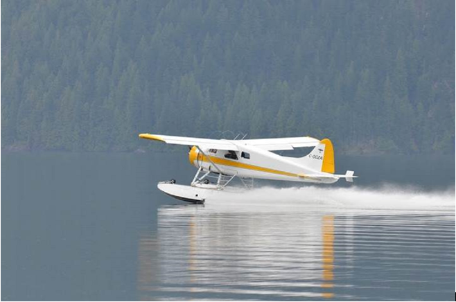
De Havilland DHC-2 Beaver Collision with Terrain
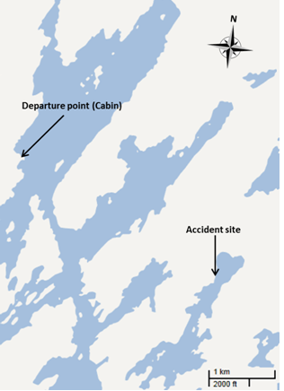
The float-equipped de Havilland DHC-2 departed from a lake adjacent to a remote fishing cabin near Buss Lakes for a day VFR flight to Southend, Saskatchewan, about 37 nautical miles (nm) southeast. There were 4 passengers and 1 pilot onboard. The aircraft crashed along the shoreline of another lake located about 2 nm southeast of its point of departure. The impact was severe and the 5 occupants were killed on impact. The emergency locator transmitter activated, and the aircraft was found partially submerged in shallow water.
The pilot was certified and qualified in accordance with existing regulations. On 30 June, the pilot's total flying time was 4023 hours with 3664 hours on float-equipped aircraft.
Manufactured in 1958, technical records indicated that the aircraft was certified, equipped and maintained in accordance with existing regulations and approved procedures. Prior to the float season, the aircraft underwent an 800–hour inspection by an approved aviation maintenance organization (AMO) in La Ronge, Saskatchewan, on 28 May 2011.
Images recovered from the wreckage and the meteorological assessment indicate that the pilot had waited until the weather was suitable to accomplish the flight to and from Buss Lakes. The meteorological assessment suggested that light winds would prevail during the flights. Therefore it is unlikely the flight encountered unusual winds or turbulence that would have led to the accident. The assessment suggested that local dense fog patches could have formed in the Buss Lakes area, possibly obscuring shorelines and/or higher terrain in the area. While it is unlikely the pilot would have flown into dense fog at low level, it is possible that maneuvers had to be performed to avoid it. Fog patches near the aircraft would have been a distraction and would have contributed to the pilot's workload.
The TSB investigation concludes:
- While maneuvering at low level, the aircraft's critical angle of attack was likely exceeded and the aircraft stalled.
- The stall occurred at an altitude from which recovery was not possible.

Lake Buccaneer LA-4-200 Collision with Water
At approximately 1900 Eastern Daylight Time on 03 June 2010, a Lake Buccaneer LA-4-200 amphibious aircraft with the pilot and a passenger on board departed on a visual flight rules flight from Lac de la Marmotte II to Baie Comeau, Quebec. The 98 nautical mile flight was to take approximately 1.3 hours. When the aircraft did not arrive at destination by the end of day on 04 June 2010, a search was started on the morning of 05 June 2010. Using sonar, the aircraft was located on 26 June 2010 by the Sûreté du Québec police dive team at a depth of 230 feet in Lac Berté, 5 nautical miles south of Lac de la Marmotte II. The aircraft and occupants were recovered on 02 and 03 July 2010 with the assistance of a remotely operated vehicle with underwater camera. The aircraft sustained substantial damage on impact with the surface of the water. The pilot and passenger were seriously injured and drowned. No emergency locator transmitter signal was detected by the search and rescue system.
Photos retrieved from the accident site along with environment Canada aviation weather reports confirmed that the weather conditions at the approximate time of the occurrence flight. The reflection of the sky and clouds on the surface of Lac Berté, revealed that weather was conducive to VFR flight; it was sunny with scattered clouds, winds were light to nil giving glassy water conditions for the lake surface; no thunderstorm activity or precipitation was visible in the area at the time the photos were taken.
The pilot held a valid private pilot licence since 1975 and a seaplane endorsement since 1976. Over the past several years, the pilot flew occasionally during the months of April through October, flying approximately 45 hours per year. The pilot had met all Transport Canada currency training requirements.
Records indicate that the aircraft was certified, equipped, and maintained in accordance with existing regulations and approved procedures. The last annual/100-hour maintenance inspection was completed on 03 August 2009.
The 78-year-old pilot held a valid category 3 medical certificate. The pilot's last aviation medical examination took place on 23 July 2009. In 1987, it was found that the pilot had previously had a heart attack. Also in 1987, the pilot was found to have diabetes mellitus (Type 2 diabetes). The pilot's family doctor was also aware of the pilot's health issues. The pilot was expected to complete and forward to Transport Canada, the results of various required medical tests relative to the diabetes and heart conditions, on an annual basis in order to maintain the category 3 medical certificate required for the private pilot licence. The pilot's next medical examination was due in July 2010.
The 69-year-old passenger had a heart condition. The passenger had a heart attack in 1990 followed by bypass surgery in 2000 and was taking medication for the heart, hypertension and hypercholesterolemia.
The autopsies performed did not determine that either occupant had an incapacitating medical event in flight. Heart attacks or angina attacks do not always leave markers evident in a post-mortem examination.
Neither occupant died of injuries incurred during the crash sequence. Both were seriously injured and died of drowning. The pilot had fractures to the upper maxilla (jaw bone), and both wrists. Fractures to the pilot's wrists (bracing maneuver) would likely indicate that he was conscious and at the controls at the time of the impact with the water.
It is uncommon for the TSB not to be able to determine a conclusive finding or cause of an accident however the available evidence in this case does not allow a definitive single cause. The TSB suggested two possible accident scenarios.
The first possible scenario is that the aircraft had some system malfunction that was not determined during the post-accident examination. However, this scenario would not explain why the pilot, with much experience landing on water, and with ample space on Lac Berté to make a precautionary landing, was not able to land the aircraft safely on the water. Given that the lake surface conditions were glassy, the pilot would likely have chosen to land closer to a shoreline or island in order to help judge the height above the water. The aircraft was found 1476 feet from any shoreline, which indicates that the pilot likely did not actively choose the area in which it struck the water, either because the pilot was unable to do so or the situation did not allow time to do so.
The second scenario is a sudden medical event resulting in pilot or passenger impairment while in flight over Lac Berté. The passenger took pictures during take-off, climb and cruise suggesting there was no apparent imminent danger or worry at that point during the flight.
Both the pilot and the passenger had pre-existing health risk factors making it possible that either one of them may have experienced a medical event resulting in some degree of impairment possibly leading to distraction and/or a loss of control of the aircraft.
Beechcraft Bonanza F33A - Loss of Control and Collision with Terrain
At approximately 1819 Eastern Standard Time a Beechcraft F33A aircraft departed Toronto/Buttonville Municipal Airport for Kingston Airport, Ontario, on a night visual flight rules flight with an instructor and two licenced students on board. Weather en route began to deteriorate and the aircraft was headed back to Toronto/Buttonville Municipal Airport. The aircraft was observed on radar to be westbound in level flight before it turned north and began to climb. The aircraft then turned abruptly to the left and descended; radar contact was lost. The aircraft was subsequently located in a field approximately 10 nautical miles east of the Toronto/Buttonville Municipal Airport. It was destroyed on ground impact and the three occupants were fatally injured. There was no fire and the emergency locator transmitter did not activate.
The instructor was certified and qualified for the flight in accordance with existing regulations. He held a commercial pilot licence with a group 1 instrument rating and was qualified to fly single and multi–engine land aircraft. He had accumulated approximately 900 hours as an instructor. One month prior to the occurrence he was issued a Class 1 Flight Instructor rating.
Records indicate that the aircraft was certified, equipped, and maintained in accordance with existing regulations and approved procedures.
The CYKZ forecast for the time period was generally VFR with temporarily reduced visibility to 5 miles in light rain showers and mist, with broken clouds at 2000 feet.
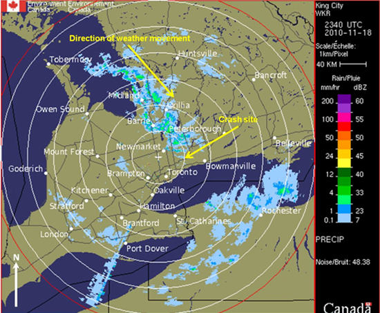
Environment Canada radar indicated precipitation in the form of rain moving in a southerly direction towards Lake Ontario from Lake Huron. The graphical area forecast (GFA) clouds and weather forecasted isolated towering cumulus clouds, 2 statute miles visibility in light snow showers with a ceiling of 1000 feet agl over and off Lake Huron. The GFA icing turbulence and freezing forecast issued at 1242 and valid at 1900 showed no icing being forecast with a freezing level at 2500 feet asl. A second GFA issued at 1832 and valid at 1900 showed moderate mixed icing between 3000 to 9000 feet asl. This forecast was not available prior to the aircraft departing CYKZ. Although no PIREPS were received prior to the occurrence, aircraft in the vicinity and at an altitude of 2500 agl, were encountering light icing conditions with mixed precipitation, and a temperature of approximately − 2°C.
Although CYKZ and CYOO airports were reporting VFR weather conditions, at the mid–point between the two, there were ground reports of rain mixed with snow with temperatures suitable to icing.
Approximately 11 nautical miles (nm) east of the Oshawa Airport (CYOO), the flight crew reported deteriorating weather conditions and decided to CYKZ.
During the return flight, radar information indicated that the aircraft maintained an altitude of approximately 2300 feet above sea level (asl) and a ground speed of 130 knots As the aircraft headed towards CYKZ, the instructor contacted the tower and requested an approach to runway 33. The clearance was given to the aircraft but no acknowledgment was provided by the instructor. There were no further radio transmissions from the aircraft.
Immediately after this last communication, the radar indicated the aircraft began a climbing right turn to a track of 330°. The airspeed reduced to approximately 90 knots IAS during the climb. The second last radar contact showed the aircraft climbing through an altitude of 2800 feet asl, and turning westbound with a further reduction to 50 knots IAS. The last radar contact at about 1843 indicated the aircraft was descending rapidly through 2100 feet asl with the IAS at 90 knots and increasing. Shortly after this radar contact with the aircraft was lost.
A police helicopter was dispatched to the same area and, using a search light, was able to locate the wreckage.
The subsequent TSB investigation concluded:
- After encountering adverse weather conditions, a climbing right turn was initiated. During the climbing turn, engine power was likely not increased and the airspeed decayed. The angle of attack on the left wing was allowed to increase until it stalled and dropped unexpectedly.
- The location of the flight instruments made it more difficult for the instructor in the right seat to see and react to them and control of the aircraft was not regained before the aircraft struck the ground in a non–survivable impact.
De Havilland Beaver - Controlled Flight into Terrain
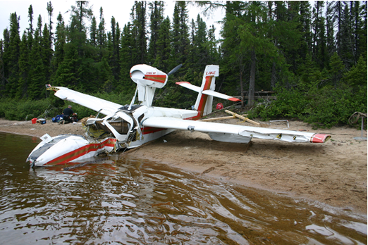
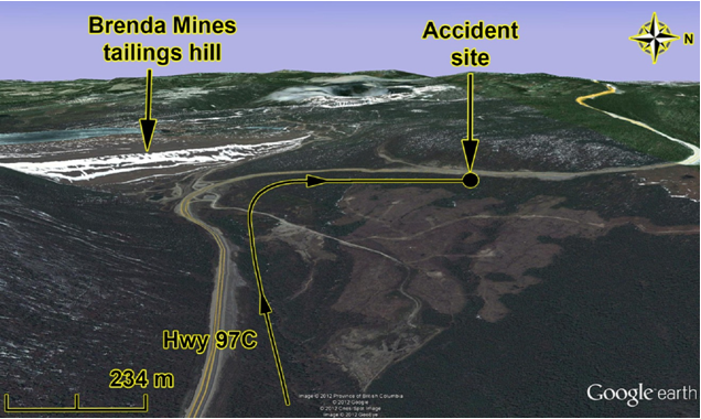
The de Havilland DHC-2 MK 1 amphibious floatplane departed Okanagan Lake, near Kelowna, for a daytime flight under visual flight rules to Pitt Meadows, British Columbia. The flight was carrying one pilot and 2 passengers. While enroute, the aircraft struck trees and collided with terrain close to and 100 feet below the level of Highway 97C, near the Brenda Mines tailings hill. Most of the aircraft was consumed by a post impact fire. The 3 occupants were fatally injured.
There were no witnesses to the crash however the Emergency Locator Transmitter activated on impact and smoke was observed by motorists on the nearby highway who called emergency response agencies.
It was determined that the aircraft was certified, equipped, and maintained in accordance with existing regulations and approved procedures. Investigators were also able to determine that the aircraft engines was producing power at the time of the impact and that mechanical failure or flight outside the operating envelope of the aircraft was not a likely factor.
There was no indication that an aircraft system malfunction contributed to this accident. There were no dramatic changes in the aircraft’s flight path, and no emergency calls from the pilot to indicate that an in-flight emergency was experienced. The constant ground speed and flight path would also suggest that the aircraft was under the control of the pilot.
The aircraft was not equipped with onboard recorders and due to the post-crash fire, there was not a significant amount of information to be gained by the subsequent analysis of the aircraft’s flight and engine instruments.
The pilot was certified and qualified for the flight in accordance with existing regulations. An experienced Beaver pilot had given the accident pilot 12 hours of dual instruction during the winter and spring of 2012, all at sea level. The accident pilot had accumulated a total of approximately 50 hours in the accident aircraft, and approximately 420 hours of total flight time.
As a result of the investigation is was discovered that the aircraft’s performance was limited by weight and density altitude. Meteorologically, there was evidence of some down-flowing air. At the same time, the pilot’s vision was likely impaired by the sun, and the pilot may have been exposed to visual illusions. These were factors that contributed to the pilot not noticing the rising terrain, and colliding with it.


Pilot Resources
Ask ATS
Weather
TSB
Interactive Materials
NOTAMs
Air Safety Institute
ELTs
Aviation Safety Letter
SmartPilot proudly works with.


We would like to acknowledge the financial support of the Government of Canada for this initiative through the Search and Rescue New Initiative Fund (SAR NIF).